
Practical information: This article provides general legal information. Advice about your circumstances requires a consultation.
How Strawberry Patch Realty and Kornitzer Law explain 15.9 acres on a county map and 13.2 acres available to sell
A fictional example of gaps and gores filled in through GIS mapping
Elena was preparing to sell a former plant nursery beside Cypress Creek. The county’s online parcel map showed 15.9 acres. Her deed and older survey described 13.2 acres. In this example, 13.2 acres is what she owns, what she is taxed on, and what she has to sell. The larger map number does not give her another 2.7 acres.
Why the county map looked larger
The deed followed straight courses from corner to corner along the southern boundary. The county’s GIS outline followed a wavy line along the creek farther south. Between those two lines were uneven strips and pockets of land.
In this scenario, a mapping review explained that the GIS process filled in those gaps and gores and included them in the displayed parcel outline. The resulting map showed 15.9 acres, even though the deed and survey area was 13.2 acres.
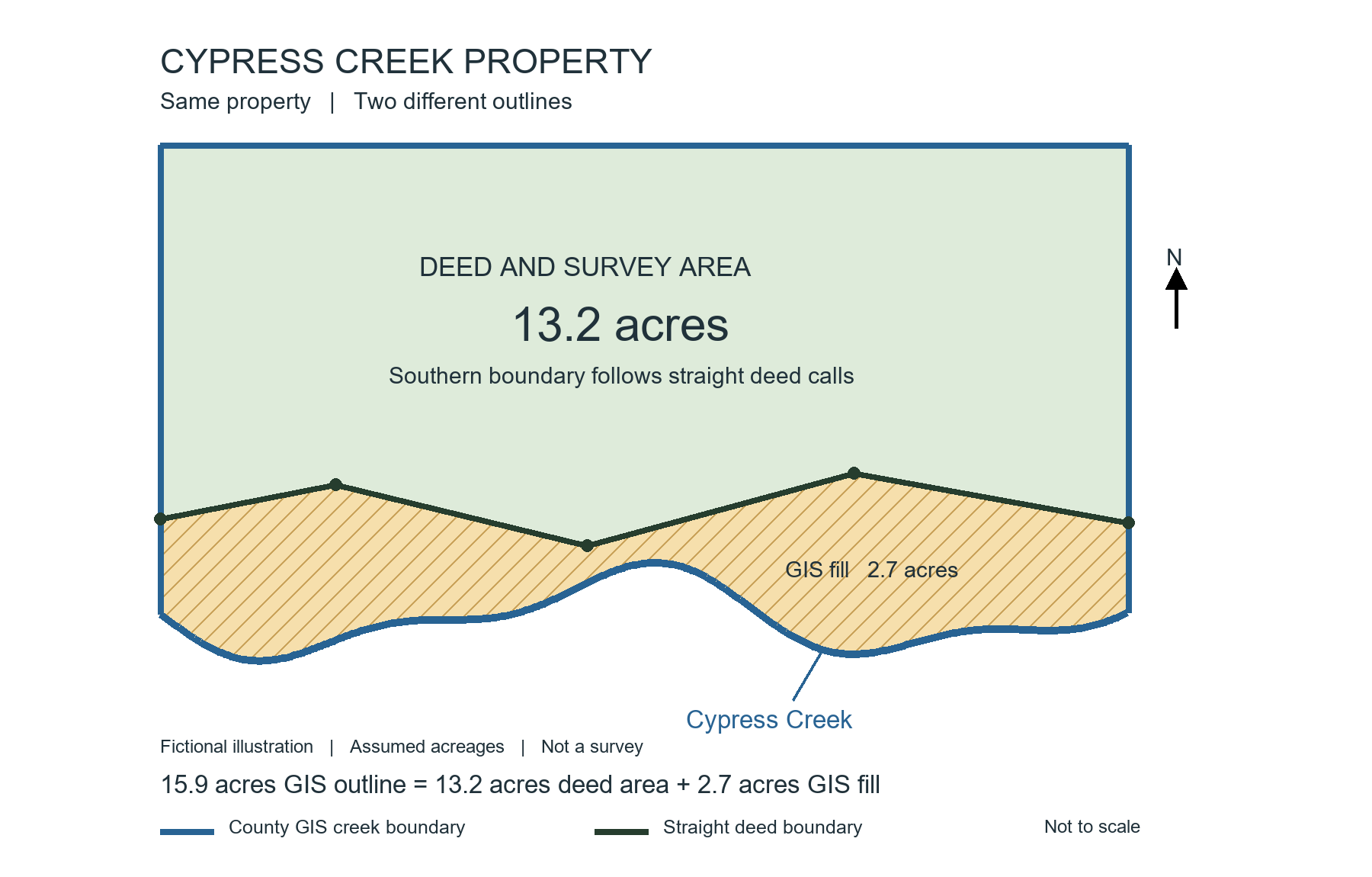
The gold area illustrates 2.7 acres included through GIS fill. The acreage and boundaries are assumed for this example. This diagram is not a survey.
What gaps and gores means
Imagine drawing the deed boundary with a ruler, then drawing a winding creek below it. The space between them forms irregular pieces. A gap is a space between boundaries. A gore is generally a narrow or oddly shaped strip of land. Here, those areas were filled into the GIS parcel display.
That explains the difference between the two numbers: 13.2 acres within the deed boundary plus 2.7 acres of GIS fill equals 15.9 acres within the online outline.
The GIS outline is subject to change
The county’s GIS map is a mapping tool. Its parcel lines and displayed acreage are subject to change as the mapping is updated or corrected. The filled area is not a conveyance of land, and the larger outline does not change Elena’s deed.
Only 13.2 acres is taxed and available to sell
In this example, the property is taxed on 13.2 acres. Elena is not paying property taxes on an additional 2.7 acres simply because it appears inside the online outline.
The 13.2 acres described by her deed is what she has to sell. The GIS fill is not hers to sell. She cannot turn a 13.2-acre conveyance into a 15.9-acre conveyance by using the county’s online acreage figure.
Title will not insure the 15.9 acres
In this scenario, the title company will not insure the property as 15.9 acres. Its coverage is tied to the 13.2-acre legal description, subject to the policy’s terms and exceptions. The extra 2.7 acres shown through GIS fill is not included as land owned by Elena and insured under that description.
How Strawberry Patch Realty and Kornitzer Law help
In this fictional review, Strawberry Patch Realty of Florida LLC compared the acreage shown online with the property materials and addressed how the property should be presented for sale. Kornitzer Law, LLC reviewed the deed, survey, and title information to explain what land Elena could convey and why the additional GIS area was not hers to sell. A licensed surveyor would address any boundary measurements requiring confirmation.
Their work brought the numbers into focus: 15.9 acres was the GIS display, subject to change. The 13.2-acre property was the land being taxed and the land available to sell.
Before advertising extra acreage, make sure it is yours to sell.
Strawberry Patch Realty of Florida LLC | patchre.comKornitzer Law, LLC | kornitzerlaw.com813-997-0733
Fictional teaching example, not a report of an actual client matter. All acreage allocations and case outcomes are assumed. General information, not a survey or a title commitment. Brokerage and legal services are provided by their separate businesses.